Difference between revisions of "Fort Ligar"
(→Summary) |
|||
| (21 intermediate revisions by 2 users not shown) | |||
| Line 1: | Line 1: | ||
| − | + | [[Image:ligar.jpg]] [[Image:Ligar 2.jpg]] | |
| − | + | * Images courtesy of (Smith 1989) | |
| − | |||
== Summary == | == Summary == | ||
| − | Fort Ligar (R11/1656), constructed in 1845, was one of at least 32 military installments built by New Zealand colonists as a result of the signing of the Treaty of Waltangi in 1840. Located in Auckland, New Zealand, Fort Ligar took the form of an earthwork redoubt, serving as a defensive installment for the residents of Auckland with a pressing fear of | + | Fort Ligar (R11/1656), constructed in 1845, was one of at least 32 [[:Category:Military | military]] installments built by New Zealand colonists as a result of the signing of the Treaty of Waltangi in 1840. Located in [[:Category:Auckland | Auckland]], [[:Category:New Zealand | New Zealand]], Fort Ligar took the form of an [[:Category:earthworks | earthwork]] redoubt, serving as a defensive installment for the residents of [[:Category:Auckland | Auckland]] with a pressing fear of attack from the North during the [http://www.nzhistory.net.nz/war/northern-war War in the North]. Although it was quick for construction to begin, Fort Ligar was never completed due to diminishing fears of attack and was demolished in 1859 (Smith 1989). |
| + | == Redoubt: == | ||
| − | + | As Walton describes in [http://www.doc.govt.nz/upload/documents/science-and-technical/DSIS122.pdf “New Zealand redoubts, stockades and blockhouses, 1840-1848,”] the redoubt, as erected at Fort Ligar, consisted of “[[:Category:earthworks | earthwork]] fortifications defended by a ditch and with the spoil thrown up to form a parapet on the interior side (Walton 2003:7).” This definition is further refined with the variation of shape and interior layout. Although redoubts of the time took a variety of forms, shapes, and defensive strategies, Fort Ligar was constructed as a rectangle with a narrow ditch that falls within a genre of elaborate in design and close to a style “more utilitarian and quickly constructed (Smith 1989:35).” Of Fort Ligar’s temporal counterparts, the more common plan of the 1840s followed a triangular shape, or smaller square, and was constructed around a pre-existing building as seen in Fort Thorndon and Te Aro (Walton 2003). Although the initial design of Fort Ligar was never completed, it was projected to be a grand monument comparable to the engineering of days once seen in England (Smith 1989). | |
| − | + | == Archaeology: == | |
| − | + | Funded by the Auckland City Council as part of the Historic Urban Archaeology Program, the archaeological investigation of Fort Ligar (R11/1656) was conducted in two phases. Phase one of the excavation (June 8-14, 1988) served as an exploratory phase to establish the survival of the Fort and its potential for further archaeological investigation. Phase two of the excavation (June 20 – July 1, 1988) served to establish the size and shape of the Fort, as well as to locate all associated sub-surface features. During this phase, features where carefully selected to be partially or completely excavated, and artifacts where recovered from clearly defined/sealed features. Archaeological Investigations revealed that much of Fort Ligar had been destroyed through various building projects through time, yet 35 meters of the associated ditch were discovered. Artifactual assemblages where recovered from 11 separate contexts, but only one dated to the Fort Ligar period from 1845 – 1859, sealed within the fill of the ditch itself (Smith 1989). | |
| + | <googlemap lat="-36.848292" lon="174.761742" zoom="19"> | ||
| + | -36.848432, 174.761742, Fort Ligar | ||
| + | </googlemap> | ||
| − | + | Investigations of Fort Ligar discovered a history that had been forgotten in time and space, only to be revealed by the trowel. Seen within the incompleteness of the surrounding ditch and financial concerns within historical documentation, it can be said with confidence that Fort Ligar was never completed. Artifacts recovered from the loan sealed context within the ditch reveal a Fort Ligar that was casually occupied while the city of [[:Category:Auckland | Auckland]] developed around it. It is apparent that the ongoing construction the Fort served as more or less a fallowing reassurance to the inhabitants of [[:Category:Auckland | Auckland]] while fear grew and quickly settled. Ian Smith best assesses the intention behind the Fort’s construction by noting, “Fort Ligar was just such a measure - visible, reassuring, physically occupying many of the townspeople, and at limited expense to the financially strapped Colony (Smith 1989:41).” | |
| − | |||
| − | + | Excavation of later contexts of the [[:Category:Historic | Historic period]] at Fort Ligar revealed an [[:Category:Auckland | Auckland]] that quickly transformed from residential to commercial in the years after the War. The plot where Fort Ligar stood, once located on the town’s perimeter, commanding a view of the entire [[:Category:West Auckland | western portion]], was quickly replaced for commercial use and surrounded by development that absorbed it into the deep interior of the town (Smith 1989). | |
| − | == Publications: == | + | == References/Publications: == |
[http://www.doc.govt.nz/upload/documents/science-and-technical/IR40.pdf Smith, I. 1989. Fort Ligar: a colonial redoubt in central Auckland. New Zealand Journal of Archaeology 11:117–141.] | [http://www.doc.govt.nz/upload/documents/science-and-technical/IR40.pdf Smith, I. 1989. Fort Ligar: a colonial redoubt in central Auckland. New Zealand Journal of Archaeology 11:117–141.] | ||
[http://www.doc.govt.nz/upload/documents/science-and-technical/DSIS122.pdf Walton, A. 2003: New Zealand redoubts, stockades and blockhouses, 1840–1848. DOC Science Internal Series 122. Department of Conservation, Wellington. 15p.] | [http://www.doc.govt.nz/upload/documents/science-and-technical/DSIS122.pdf Walton, A. 2003: New Zealand redoubts, stockades and blockhouses, 1840–1848. DOC Science Internal Series 122. Department of Conservation, Wellington. 15p.] | ||
| + | |||
| + | [http://www.doc.govt.nz/upload/documents/science-and-technical/IR40.pdf Ian Smith, 1989: REDISCOVERING FORT LIGAR: ARCHAEOLOGY AT R11/1656, AUCKLAND. Department of Conservation.] | ||
| + | |||
| + | [[Category:Auckland]][[Category:Excavations]][[Category:Historic]][[Category:Military]][[Category:New_Zealand]] | ||
| − | [[Category: | + | [[Category:1989]] |
Latest revision as of 16:49, 20 March 2010
- Images courtesy of (Smith 1989)
Summary
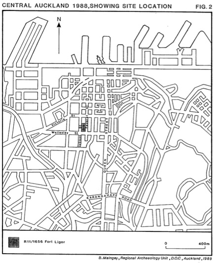
Fort Ligar (R11/1656), constructed in 1845, was one of at least 32 military installments built by New Zealand colonists as a result of the signing of the Treaty of Waltangi in 1840. Located in Auckland, New Zealand, Fort Ligar took the form of an earthwork redoubt, serving as a defensive installment for the residents of Auckland with a pressing fear of attack from the North during the War in the North. Although it was quick for construction to begin, Fort Ligar was never completed due to diminishing fears of attack and was demolished in 1859 (Smith 1989).
Redoubt:
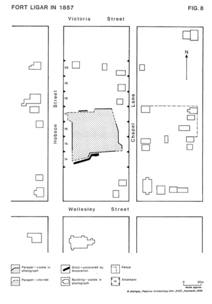
As Walton describes in “New Zealand redoubts, stockades and blockhouses, 1840-1848,” the redoubt, as erected at Fort Ligar, consisted of “ earthwork fortifications defended by a ditch and with the spoil thrown up to form a parapet on the interior side (Walton 2003:7).” This definition is further refined with the variation of shape and interior layout. Although redoubts of the time took a variety of forms, shapes, and defensive strategies, Fort Ligar was constructed as a rectangle with a narrow ditch that falls within a genre of elaborate in design and close to a style “more utilitarian and quickly constructed (Smith 1989:35).” Of Fort Ligar’s temporal counterparts, the more common plan of the 1840s followed a triangular shape, or smaller square, and was constructed around a pre-existing building as seen in Fort Thorndon and Te Aro (Walton 2003). Although the initial design of Fort Ligar was never completed, it was projected to be a grand monument comparable to the engineering of days once seen in England (Smith 1989).
Archaeology:
Funded by the Auckland City Council as part of the Historic Urban Archaeology Program, the archaeological investigation of Fort Ligar (R11/1656) was conducted in two phases. Phase one of the excavation (June 8-14, 1988) served as an exploratory phase to establish the survival of the Fort and its potential for further archaeological investigation. Phase two of the excavation (June 20 – July 1, 1988) served to establish the size and shape of the Fort, as well as to locate all associated sub-surface features. During this phase, features where carefully selected to be partially or completely excavated, and artifacts where recovered from clearly defined/sealed features. Archaeological Investigations revealed that much of Fort Ligar had been destroyed through various building projects through time, yet 35 meters of the associated ditch were discovered. Artifactual assemblages where recovered from 11 separate contexts, but only one dated to the Fort Ligar period from 1845 – 1859, sealed within the fill of the ditch itself (Smith 1989).
<googlemap lat="-36.848292" lon="174.761742" zoom="19"> -36.848432, 174.761742, Fort Ligar </googlemap>
Investigations of Fort Ligar discovered a history that had been forgotten in time and space, only to be revealed by the trowel. Seen within the incompleteness of the surrounding ditch and financial concerns within historical documentation, it can be said with confidence that Fort Ligar was never completed. Artifacts recovered from the loan sealed context within the ditch reveal a Fort Ligar that was casually occupied while the city of Auckland developed around it. It is apparent that the ongoing construction the Fort served as more or less a fallowing reassurance to the inhabitants of Auckland while fear grew and quickly settled. Ian Smith best assesses the intention behind the Fort’s construction by noting, “Fort Ligar was just such a measure - visible, reassuring, physically occupying many of the townspeople, and at limited expense to the financially strapped Colony (Smith 1989:41).”
Excavation of later contexts of the Historic period at Fort Ligar revealed an Auckland that quickly transformed from residential to commercial in the years after the War. The plot where Fort Ligar stood, once located on the town’s perimeter, commanding a view of the entire western portion, was quickly replaced for commercial use and surrounded by development that absorbed it into the deep interior of the town (Smith 1989).

