Difference between revisions of "Mt Wellington Maungarei - Visit"
(→What:) |
(→What:) |
||
| (7 intermediate revisions by the same user not shown) | |||
| Line 17: | Line 17: | ||
}} | }} | ||
===Location:=== | ===Location:=== | ||
| − | |||
| − | |||
| − | |||
| − | |||
| − | |||
| − | |||
| − | |||
| + | <html> | ||
| + | <body> | ||
| + | <iframe width="425" height="350" frameborder="0" scrolling="no" marginheight="0" marginwidth="0" src="https://www.openstreetmap.org/export/embed.html?bbox=174.83754158020022%2C-36.89752050923259%2C174.85397815704346%2C-36.88773872308422&layer=mapnik" style="border: 1px solid black"></iframe><br/><small><a href="https://www.openstreetmap.org/#map=16/-36.8926/174.8458">View Larger Map</a></small> | ||
| + | </body> | ||
| + | |||
| + | </html> | ||
===What:=== | ===What:=== | ||
| − | Prehistoric Maori fortification and place of residence built on a volcanic cone. There is little on site interpretation. It is one of the better preserved cone pa in the Auckland field. | + | Prehistoric Maori fortification and place of residence built on a volcanic cone. There is little on-site interpretation. It is one of the better preserved cone pa in the Auckland field. |
| + | |||
| + | It is also relatively recent, so the volcanic material is less weathered. There is more exposed scoria than most of the other cones. Covered footwear is recommended. | ||
| + | |||
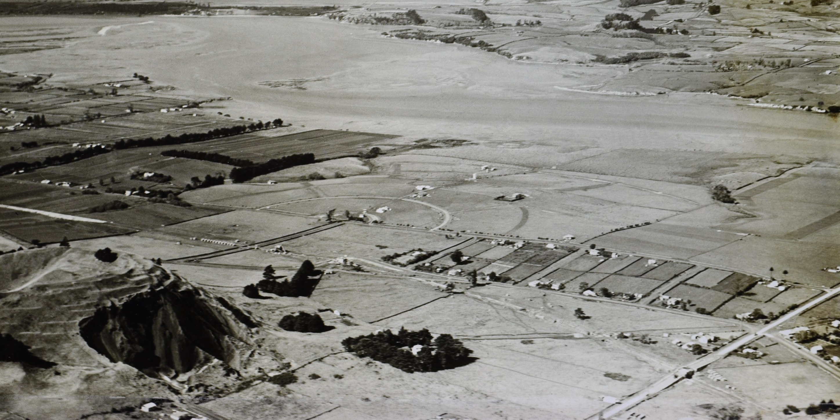
| + | [[File:Mt well quarry.jpg]]An older aerial of the maunga when it was still being quarried. Photo by: F. Douglas Mill. circa 1928 | ||
| + | Auckland Libraries Heritage Collection FDM-08988-P | ||
| Line 39: | Line 43: | ||
===What else to do there:=== | ===What else to do there:=== | ||
| + | |||
| + | The Maungarei stonefields archaeological site is at the foot of the mountain. http://archaeopedia.com/wiki/index.php?title=Maungarei_Stonefields_-_Visit | ||
Views over the eastern city. | Views over the eastern city. | ||
| Line 45: | Line 51: | ||
Sylvia Park, New Zealand's largest shopping mall is only a short distance away. | Sylvia Park, New Zealand's largest shopping mall is only a short distance away. | ||
| − | |||
| − | |||
| − | |||
| − | |||
| − | |||
===Web Info:=== | ===Web Info:=== | ||
| + | Maunga Authority: https://www.maunga.nz/maunga/maungarei/ | ||
| − | + | Wikipedia page: https://en.wikipedia.org/wiki/Maungarei | |
| − | |||
| − | |||
| − | |||
| − | |||
Latest revision as of 22:19, 30 January 2023
Contents
Mt Wellington Maungarei - Visit
| SITE TO VISIT | |
|---|---|
| Mt Wellington | |
| Maungarei | |
| | |

| |
| Ethnicity: | Maori |
| Site type: | Pa |
| Where: | East Auckland - 20 minutes from the city centre |
| How to get there: | Bus, Train (Check Rideline) or taxi. |
| How Long to allow: | 1 hr walking over the site. |
| Disclaimer | |
Location:
View Larger Map
What:
Prehistoric Maori fortification and place of residence built on a volcanic cone. There is little on-site interpretation. It is one of the better preserved cone pa in the Auckland field.
It is also relatively recent, so the volcanic material is less weathered. There is more exposed scoria than most of the other cones. Covered footwear is recommended.
 An older aerial of the maunga when it was still being quarried. Photo by: F. Douglas Mill. circa 1928
Auckland Libraries Heritage Collection FDM-08988-P
What else to do there:
The Maungarei stonefields archaeological site is at the foot of the mountain. http://archaeopedia.com/wiki/index.php?title=Maungarei_Stonefields_-_Visit
Views over the eastern city.
Panmure Basin has a circumferential walk with a bridge over the entrance.
Sylvia Park, New Zealand's largest shopping mall is only a short distance away.
Web Info:
Maunga Authority: https://www.maunga.nz/maunga/maungarei/
Wikipedia page: https://en.wikipedia.org/wiki/Maungarei