Difference between revisions of "Nihotupu Auxiliary Dam - Visit"
m |
|||
| (17 intermediate revisions by the same user not shown) | |||
| Line 18: | Line 18: | ||
Waitakere Ranges Regional Park, on Ian Wells Track to the north of Piha Rd. It is a well formed track - the site is about 400 m along the track. | Waitakere Ranges Regional Park, on Ian Wells Track to the north of Piha Rd. It is a well formed track - the site is about 400 m along the track. | ||
| − | + | {{#display_map: | |
| − | + | -36.9327,174.5571~Nihotupu Auxiliary Dam; | |
| − | + | | height= 400px | |
| − | + | | width= 600px | |
| − | + | | type=satellite | |
| + | | zoom=16 | ||
| + | }} | ||
| + | |||
| + | |||
== What: == | == What: == | ||
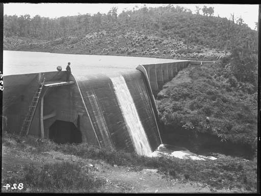
| + | [[Image:Wink niho.jpg|framed|right|Winkelmann, Henry, 1860-1931, photographer, Auckland Museum Collection PH-NEG-824]] | ||
| + | A concrete buttress dam built 1919 - 1921 by Auckland City Council. It was built at the same time as Upper Nihotupu Dam to supplement its storage. It is on the same stream and upstream of the upper dam. Its storage volume was much less than its related dam. Normal operation was to leave it full and only drain it into the upper dam when that dam was drawn down and there was potentially a need for the water from the auxiliary dam. This happened a few times in its life. | ||
| + | |||
| + | Buttress dams are relatively rare in New Zealand. This was the only one in the Auckland supply system. The buttresses were unreinforced concrete and the sloping dam face supported by the buttresses was steel reinforced. | ||
| + | Harvey Stewart's history of the Nihotupu Valley water supply dams gives more information [[http://archaeopedia.com/wiki/index.php/Water_From_the_West Water from the West]]. | ||
| + | A review of its safety by Garry Law in the 1980s indicated its stability was marginal. The stored volume was by that time of little significance and the cost of strengthening or replacing the dam prohibitive. It was decommissioned by cutting openings through the two central slabs and collapsing the sections removed onto the valley floor. | ||
== What else to do there: == | == What else to do there: == | ||
| + | The revegetation of the former lake bed is proceeding largely by natural processes and indicates recruitment and growth in the passage of time since the decommissioning. | ||
| + | To the south of Piha Road is a track starting at a car park to Upper Nihotupu dam reaching first the lake and further on the dam. | ||
| + | Drive on to Piha - one of Auckland's treasures. | ||
== External Sources == | == External Sources == | ||
| + | [https://en.wikipedia.org/wiki/Upper_Nihotupu_Reservoir Wikipedia Upper Nihotupu Dam] | ||
| + | |||
| + | [http://burpeesforlife.com/ian-wells-track-piha-regional-park/ Ian Wells Track] | ||
[[Category:Auckland Sites to Visit]][[Category:Auckland]] | [[Category:Auckland Sites to Visit]][[Category:Auckland]] | ||
Latest revision as of 18:25, 10 June 2024
| SITE TO VISIT | |
|---|---|
| Nihotup Auxiliary Dam | |
| ' | |
| | |
| | |
| Ethnicity: | European |
| Site type: | Water Supply Dam |
| Where: | Waitakere Ranges Regional Park, on Ian Wells Track to the north of Piha Rd. |
| How to get there: | Car |
| How Long to allow: | 45 Minutes |
| Disclaimer | |
Location
Waitakere Ranges Regional Park, on Ian Wells Track to the north of Piha Rd. It is a well formed track - the site is about 400 m along the track.
What:
A concrete buttress dam built 1919 - 1921 by Auckland City Council. It was built at the same time as Upper Nihotupu Dam to supplement its storage. It is on the same stream and upstream of the upper dam. Its storage volume was much less than its related dam. Normal operation was to leave it full and only drain it into the upper dam when that dam was drawn down and there was potentially a need for the water from the auxiliary dam. This happened a few times in its life.
Buttress dams are relatively rare in New Zealand. This was the only one in the Auckland supply system. The buttresses were unreinforced concrete and the sloping dam face supported by the buttresses was steel reinforced.
Harvey Stewart's history of the Nihotupu Valley water supply dams gives more information [Water from the West].
A review of its safety by Garry Law in the 1980s indicated its stability was marginal. The stored volume was by that time of little significance and the cost of strengthening or replacing the dam prohibitive. It was decommissioned by cutting openings through the two central slabs and collapsing the sections removed onto the valley floor.
What else to do there:
The revegetation of the former lake bed is proceeding largely by natural processes and indicates recruitment and growth in the passage of time since the decommissioning.
To the south of Piha Road is a track starting at a car park to Upper Nihotupu dam reaching first the lake and further on the dam.
Drive on to Piha - one of Auckland's treasures.
