Canterbury Earthquake Archaeology
Contents
Canterbury Earthquake Archaeology
The Earthquakes
The Richter scale 7.1 quake (The Darfield Earthquake) which struck on September 4, 2010[1][2] caused widespread damage and two serious injuries.The Richter scale 6.3 aftershock quake which hit at 12:51pm on February 22, 2011[3][4] caused severe damage and resulted in the loss of 185 lives. There have been many other aftershocks but much less damage is associated with those.
The discrepancy between the Richter scale measure and the damage and casualties relates to where the epicentres were. The September 4 quake was centred 40 km from Christchurch while the February 22 aftershock was within the urban boundary. Consequently the MM scale felt intensities in central Christchurch were: September 4: about VI, February 22: MM VIII. Both earthquakes caused widespread liquefaction which damaged buildings and infrastructure, both in Christchurch and in some smaller outlying communities.
Both caused damage to buildings. The February 22nd quake particularly damaged or collapsed many older masonry buildings, damaged many new buildings – some beyond repair and collapsed a few relatively new buildings. It also caused severe rockfalls on Banks Peninsula which in turn caused damage and casualties.
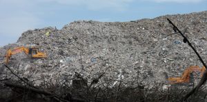
Many heritage buildings were affected. Some were destroyed. Demolition orders have been issued for many that were dangerous or beyond reasonable repair.
Google Maps view of the Christchurch CBD - post clearance. http://goo.gl/maps/zdRa1
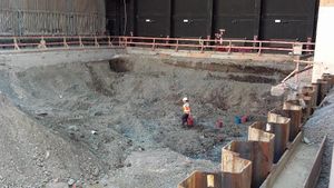
Archaeological Response
A major archive of archaeological reports is University of Canterbury CEISMIC – search for archaeology or archaeological. http://www.ceismic.org.nz/
NZHPT page on its role: http://www.historic.org.nz/protectingourheritage/faqs-earthquake.aspx?sc_lang=en
Christchurch City Council heritage page http://www.ccc.govt.nz/cityleisure/artsculture/christchurchheritage/index.aspx
CERA, Canterbury Earthquake Recovery Authority, heritage buildings and places page http://cera.govt.nz/recovery-strategy/cultural/heritage-buildings-and-cultural-heritage-places-recovery-programme
A blog about Christchurch Archaeology: Christchurch Uncovered http://blog.underoverarch.co.nz/
The work has received some international attention¨http://news.nationalgeographic.com/news/pictures/130221-christchurch-new-zealand-2011-earthquake-demolition-science-archaeology-artifacts-pictures/
External Links
NZHPT Lost Heritage page http://www.historic.org.nz/theregister/heritagelost/lostheritagecantyearthquakes/lostheritagecanterburyearthquakeschristchurcha-c.aspx?sc_lang=en
The Press - Rebuild progress pictures 2011 -2012 http://www.stuff.co.nz/the-press/news/christchurch-earthquake-2011/7002610/Rebuild-one-year-on
Aerial photos showing the extent of CBD clearance http://catalystrecruit.wordpress.com/2012/11/09/christchurch-cbd-but-not-as-you-know-it/
References
- ↑ Wikipedia 2010 Canterbury Earthquake http://en.wikipedia.org/wiki/2010_Canterbury_earthquake
- ↑ Geonet 2010 Canterbury Earthquake http://info.geonet.org.nz/display/quake/M+7.1,+Darfield+(Canterbury),+4+September+2010
- ↑ Wikipedia 2011 Canterbury Earthquake http://en.wikipedia.org/wiki/2011_Christchurch_earthquake
- ↑ Geonet 2011 Canterbury Earthquake http://info.geonet.org.nz/display/quake/M+6.3%2C+Christchurch%2C+22+February+2011

